After reading Part I of this story, we’re all essentially on the same page with what we know about the story of George Mallory & Andrew Irvine.
Now, the fun part: What do we, or more precisely, what do I, hypothesize happened to them on that fateful day, June 8, 1924?
Let’s begin…But first, a bit of reference for you. Below is a Zoom.It photo of the North Face of Everest with some key features marked. It is pretty high-resolution, as you will see, composed of about 20 shots I took in 2004 and stitched together. (Apologies in advance for the lack of dust removal…Too many specks to deal with!)
Knowing the virtues of an alpine start, Mallory would have insisted that the pair get an early start to the climb toward the summit. However, we know that they could not have left too early in the day – not before the first light of dawn illuminated the landscape – because their teammate, Noel Odell, found their head torches left behind in Camp VI. But, we can safely assume that they left sometime around first light, which would have come at roughly 4:30 AM. (While the sun hasn’t risen at this point, in my experience it is more than bright enough by 4:30 AM to move without artificial light.)
Climbing upward along the North Ridge, Mallory & Irvine would have encountered little difficulty en route to the Northeast Shoulder. Scrambly rock, similar to that of the lower North Ridge, is the only challenge…along of course with the extreme altitude.
From the Northeast Shoulder – having stood there myself in 2004 and gazed upward at the possible route options – they would have taken the most prominent and obvious line up through the Longland Traverse and on to the Northeast Ridge via the upper section of the modern “climbers’ gullies”. Again, the climbing, while interesting, is never very difficult in any part thus far and I’m confident they would have covered it relatively quickly and efficiently. Additionally, the route finding is minimal as the Longland Traverse to the climbers’ gullies is the obvious path from the Northeast Shoulder to the Northeast Ridge. (You can see a video I shot from here in 2004 on YouTube.)
Once on the Northeast Ridge, things for Mallory & Irvine would have inevitably gotten more, well, more interesting. Being ridge climbers, their habit would be to stick to the ridgecrest as much as possible. But, massive cornices overhanging the daunting Kangshung Face would understandably push them away from the crest from time to time as they moved toward the summit. The first obstacle would come after about an hour on the Ridge: The First Step.
Roughly 60 feet of rotten rock and crumbling snow, the First Step causes little more than a spate of breathlessness for climber’s today, who have the fortune of a known route that is well fixed with rope. But, for Mallory & Irvine, it would be a different story. Take the ridgeline, or the middle route up steeper rock? Try to circumvent the Step as a whole, cutting down onto the North Face below the Gray Band?
Again, being ridge climbers, my bet is they would have taken the ridgecrest. I investigated this option in 2004, and found it to be quite reasonable and well within Mallory’s climbing ability. Soon, they would be on top of the First Step, looking at an inspiring – and daunting – view.
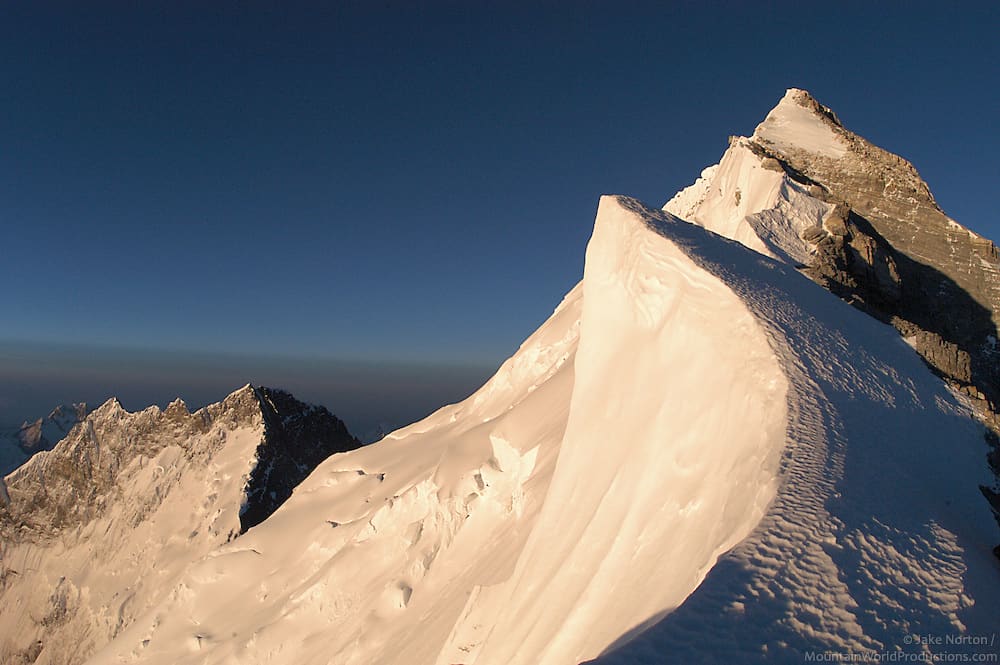
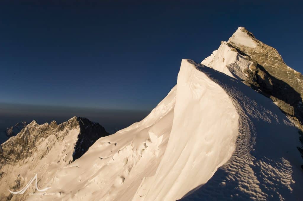
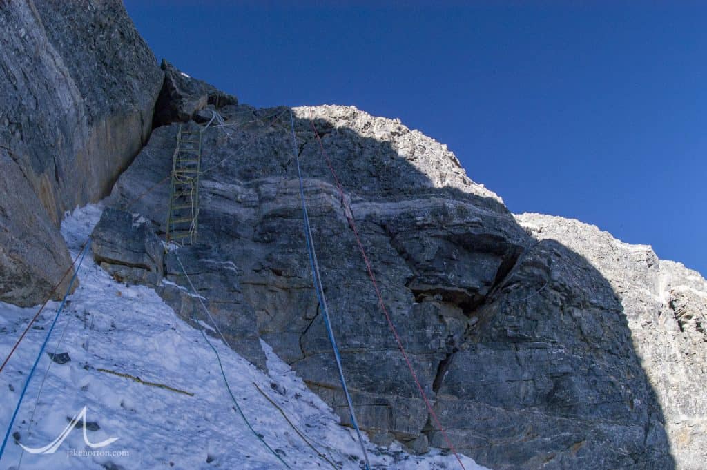
From the top of the First Step, one gazes upward at the enticing and alluring summit. It seems close at this point, tantalizingly close. But, you also see from here the at-times-impossibly-serrated Northeast Ridgecrest slicing skyward with fin-like cornices and imposing rock bands. Most impressively, from here you see the great Second Step, an 80-foot saw-toothed jag of rock sticking like a ship’s prow out of the ridge. Daunting today…it must have been terrifying in 1924.
But, again, just behind the Second Step, the summit looms, luring like a siren song. Despite the perhaps slower pace than they had anticipated, I’d be willing to bet Mallory & Irvine pushed on.
Again, the desire to climb the ridge directly would be at odds here with the topography. Cornices, steep jags of rock, and enticing “sidewalks” of limestone all force one downward, off the ridge and onto the North Face. But, that’s not where Mallory & Irvine wanted to go. On June 4, 1924, Teddy Norton and his companion, Howard Somervell, chose to keep off the Northeast Ridge, thinking the Second Step posed too great of an obstacle. They instead traversed the North Face to the Great Couloir, where Norton was finally turned around at 28,165 feet. Seeing Norton’s failure, I think Mallory would have been inclined to give the Ridge a try and see what lay in store.
(Note that Norton and Somervell were climbing without supplemental oxygen. Norton’s oxygenless altitude record would stand for 54 years, until it was bested by Reinhold Messner and Peter Habeler in 1978 when they climbed Everest without oxygen. Amazing.)
So, they climbed on, tiptoeing along the knifeblade, scurrying around boulders and across narrow, harrowing traverses. They passed Mushroom Rock which, at 28,100 feet, is the gateway to the Second Step, and a good resting point.
Where to go from here? I can only imagine how vexing this question must have been for them. Directly ahead, along the ridge, cornices sweep wildly outward, their great fins of snow hanging some 40-50 feet over the Kangshung Face. Slightly right, to the west, thin bands of rotten rock angle below the ridge into unknown terrain. Again, this is an easy point for us modern climbers: fixed lines guide the way and tell us everything but where to put each foot and how often to breath. But, not so for Mallory & Irvine. This was no-man’s land. And an unforgiving one at that.
My bet is that they first tried the ridge itself, treading a fine line between the rock and the snow moving toward the Second Step. But, this attempt would, I think, soon end when the icy crest of the Second Step came fully into view, a vertical, thin jag of corniced snow overhanging the Kangshung Face. Not appetizing today, and not in 1924.
Now, a frustrating about-face, with Mallory & Irvine retracing their steps back to Mushroom Rock.
What do they do here? It’s getting late. They are tired, and running low on oxygen. The weather is far from perfect, with pre-monsoon squalls buffeting the mountainside.
But, there ahead lies the Holy Grail, the summit of Everest…It seems so close, so tantalizingly close. Fame, fortune, glory, security…All of it was wrapped up in that summit, that patch of snow, for Mallory, and to some extent for Irvine. As a friend of mine said, the only way home for Mallory was, strangely, via the Top of the World.
Thus, I think they pushed on. I think, despite the lateness of the day, despite the fatigue they must have felt throughout their bodies, despite the fact that they were low on oxygen…despite all of these things, all of these things that Mallory’s years of experience in the mountains had taught him…I think they pushed on. I think Mallory had to push on. As his friend, Geoffrey Winthrop Young wrote, Mallory would not have turned around high on the Northeast Ridge – could not have turned around – simply because Mallory was Mallory.
And, I’ve been there myself. In 1999, I was at Mushroom Rock with Dave Hahn, Conrad Anker, Tap Richards, Ang Pisang Sherpa, and Dawa Sherpa. It was too late in my estimation to continue climbing and leave a window of safety for our return. Storms were creeping in, clawing up the valleys from Nepal. But, there was the summit, luring me onward. It was a climb I had dreamed about since I was 8, and finally, after a long 17 years, I was there, close, almost to the top. Making the decision to turn around – which I know was the right one for me that day – was agonizing, heart wrenching, the hardest decision I’ve ever had to make in the hills.
And, I wasn’t in position to be the first. I didn’t have an entire nation waiting with baited breath for me to reach the top. My reaching the summit would not have meant financial security for me and my family. Mallory, on the other hand (and to a lesser extent, Irvine), had all these pressures, and probably more.
So, they pushed on, they got summit fever. It wasn’t smart, it wasn’t noble…It was a sad decision, a regrettable one, but strangely understandable.
Taking a new route, investigating the natural lines of the mountain, they follow the strata slightly westward, off the ridgecrest and into the clefts of the Second Step. Here they see an option, a choice: leading to the west, onward in a traverse across the face, are the strata, which seem to lead out to the Great Couloir. Again, knowing what Norton encountered four days before, they don’t want to repeat his efforts. But, just to the left of them they see a break, a weakness in the defenses of the Second Step…but not much of one.
Just above, wind sculpted rock corkscrews upward to a snowy platform below a final, 15-foot, imposing headwall of vertical rock which leads to the top of the Second Step. Not easy, not simple, not secure, but a weakness, an option, a possibly opportunity. Being a skilled rock climber, one of the best of his generation, Mallory moves toward it with Irvine in tow, roped up behind. The Corkscrew Chimney, as we call it today, is awkward and exposed. There is no grace when ascending it – at least not for me – but rather a lot of grunting and scraping and swearing and clawing. But, it’s not really hard either – just awkward and exposed. And, this is perhaps the one area where a tweed coat and woolen knickers might have had a distinct advantage over a down suit: Mallory & Irvine could have seen their feet, whereas we modern day climbers are warm, but our view from the waist down is revoked by piles of down and nylon. I think, with that slight advantage, Mallory would have moved through the Corkscrew with relative ease and, from the final snow platform before the headwall, would have belayed Irvine up to him.
And now the “fun” began. Fifteen feet. Steep. Exposed. An off-width crack to the left. A crumbly, angled crack to the right. Ten thousand feet of air directly below. No chance for a mistake. No room for error. No second chance. What on earth did they do here?
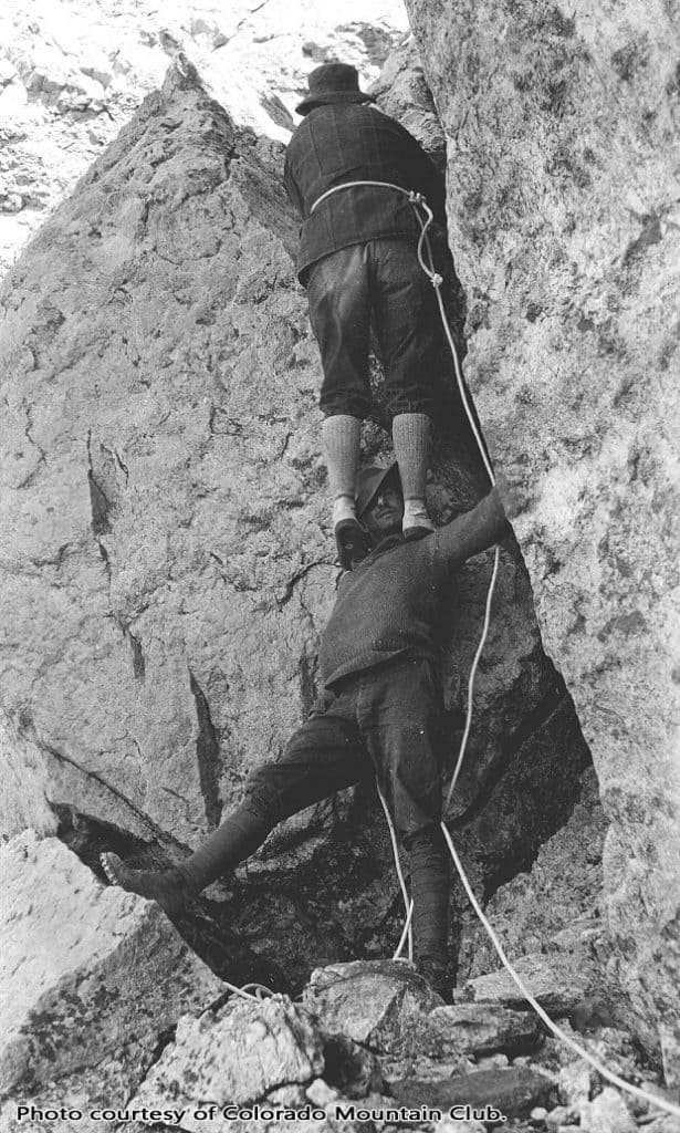
The answer never dawned on me until I started working for the American Mountaineering Museum in late-2007. My friend, Chris Case, was editing a new brochure for the “Friends of the Museum”, and chose as the cover shot a perfect image: legendary Colorado climber Albert Ellingwood scaling a steep section of rock in the 1920’s by means of the shoulders and then the head of his climbing companion, Carl Blaurock. The technique is known as a “Courte-echelle”.
If one were to use this technique at the crag today, you’d be booed and chastised and laughed at. It is simply not acceptable technique by today’s climbing standards. But, in 1924…things were different. (This technique was noted by Ullman in Kingdom of Adventure, and also appears in a 1945 issue of Life Magazine.) And, they were especially different in 1924 at 28,300 feet on the Second Step.
Andrew Irvine, standing at over 6 feet tall, would have been a good series of hand and foot holds for Mallory. With his feet planted firmly on Irvine’s head, Mallory could just reach the top portion of the Step, the point where it gets slightly less steep and some handholds appear. From there, a few scary, exposed, dangerous moves would have helped Mallory collapse, exhausted and exuberated, atop the Second Step.
(Of note is the fact that the first known ascenscionists of the Northeast Ridge – the Chinese in 1960 – used exactly this technique to get up the Second Step. The lead climber, Qu Yinhua, actually took off his boots and gloves to make it happen, eventually losing his hands and feet to frostbite…but getting through the problem nonetheless.)
Using the rope, Mallory would have belayed Irvine to the top of the Step for a well needed rest and to reconnoitre the next phase of the climb.
And from here, it was comparatively easy. The top of the Second Step leads along easy ground to the Third Step, which, once upon it, shows itself to be of little problem: a short, easy scramble leads through it to the snow slopes above.
Another 45 minutes would lead Mallory & Irvine to another choice: follow the snow directly up steep terrain, or break out onto the North Face? Although steep and daunting, I think they would have opted for the snow. They’re tired, it’s late, and they’re amazingly close now. They don’t want to risk going off to the west-southwest along possibly easier ground only to encounter another obstacle, one which they cannot surmount. So, they go straight up.
Mallory leads, agonizingly cutting steps in the styrofoam snow. It is steep, but not more so than sections of the North Col Headwall. Slowly, carefully, painstakingly, they make their way to the top. And, there, they see a great sight: the summit, the grail, the top of the world, just minutes away. It’s easy ground from here, just an undulating snow slope at a ridiculous altitude.
I believe that late in the day – dangerously, stupidly late in the day – on June 8, 1924, George Mallory & Andrew Irvine stood on that lonely patch of snow on top of the world, the first people to reach the summit of Mount Everest. (There, I said it!) It was probably sunset. The temperature was dropping. They were low on, or out of, oxygen. But, there they were, exuberant, embracing, on the summit of Everest.
And then the hard part began…they had to get back down.
What happened? What went wrong? Where did they fall, and what caused it? And, where is Andrew Irvine…and the camera?
I’ll save that for Part III of this story – stay tuned.

Jake, Like you, I believe that Mallory and Irvine made it to the summit of Everest. I have a copy of "Ghosts of Everest" and have read it several times. One day, maybe, Irvine's body (The English Dead) might be found and, if the camera lies with his body, we will know.
Thanks, Dave, and glad to hear you've enjoyed "Ghosts of Everest" over the years! Definitely a book all of us involved are quite proud of.
Like you, I hope one day Irvine will be found, and with him additional answers. But, having been there now on four dedicated search expeditions (1999, 2001, 2004, and 2019), I'm losing hope that he is still on the mountain. But, always retaining a fragment of hope for the future!
Thanks, and all best,
Jake
Thank you for your amazing article Jake. I found this article on the hypothesis of Irvine body. I hope you can get a second idea. https://thewire.in/history/mallory-irvine-second-step-everest
Hi there Jake
Cant keep away from M@I sleuthing.
Thom Pollard tells of a potential removal of Irvines body by the Chinese. Plus some deliberate damage to his head which is awful if true. He claims it is based on solid evidence. Not sure what to make of this. Cheers Alex
Me, neither! It's always there, prickling in the back of my head, questions swirling, possibilities snaking outward and inward. You're not alone! And, I'm overdue for some more M&I posts on this site, hopefully soon.
As for Thom's info, I've heard the same through the ether. Sounds like Irvine may have been found in the early-2000s by the Chinese. I've heard conflicting dates, some putting it at 2003 or 2004, and others dating it around 2007 or 2008. Seems hard to believe to some degree: I was there in 2003 shooting for Outdoor Life Network, and in 2004 with Dave Hahn searching, and likely would have heard about goings on like that in those years. And, of course, Conrad was there with Leo in 2007, and Jochen in 2008. That's not to say it didn't happen, and maybe my disbelief is rooted in a desire for it not to be true, for if true it would render the mystery in a veritable cul-de-sac.
On the damage, I have not heard of this, but it would be sad if so. Rumors that have percolated to me range from Irvine having been removed (i.e., pushed down the mountain, likely into the Central Rongbuk), and even that he was brought down and is interned somewhere in Lhasa. Sadly, we likely won't know much more unless someone decides to speak up from China.
I hope you're well, my friend. On a side note, I'm considering setting up a forum/community on my website where all of us M&I fanatics can communicate in a controlled space and discuss info, evidence, theories, etc. All would be welcome, so long as conversation remains civil. Do you think there would be interest in it? I know most of the old M&I forums are defunct (Delphi, Pete Poston's, etc.). Thanks again, and be well, Alex.
Thanks Jake
I hope he is still up there under some snow and rocks and will be found though the searches so far have been extensive from what I have read. Tracy took a picture in 2013 which looked very interesting and matched the fall line.
Hopefully the 2024 anniversary will spark some more interest and a renewed search.
Would be certainly interested in MI community discussion if it can be put together. Keeping it civil and free from crazies might be a challenge. Some topics like the ridge or couloir route, summit or no summit, how they fell and died could be covered. I have thoughts on all these but am keen to hear other views.
Hope you are going well in Colorado. We are facing renewed lockdowns in NSW and maybe Canberra.
Regards Alex
Thanks, Alex. I'll have to find that Tracy picture; I'm always interested in his theories and research.
Agreed that hopefully 2024 will spark some more interest and information, but wonder if the Chinese will be amenable to much going on. We shall see.
And, on the M&I community, I'm looking into options, and will keep you and others posted. I'm off to Tanzania in a couple days, so won't be until after mid-August when I return.
Sorry to hear about lockdowns for you. We haven't hit them yet, but likely should the way Delta is raging across the country, especially amongst unvaccinated populations. Sad to see.
Be well,
Jake
BTW I really enjoyed your theory on a possible summit climb via the ridge. Takes some courage to argue they made it. Tom Holzel was in a recent podcast with Thom Pollard and he is adamant they had no chance and got held up at second step.
I still have no idea.
Yeah, I still do believe they made it, and am certainly convinced they could have. As I've written, I have less trouble envisioning how they'd get up the Second Step then getting back down it again. The reality is the lower section (often called the Corkscrew Chimney) is not very difficult. The final headwall, in my opinion, could have been done like the Chinese did in 1960 - and was very common in the 1920s - using a courte-échelle move with Mallory standing on Irvine's shoulders and/or head to reach near the top of the Step.
Again, to me, the big challenge with the Ridge is how they'd get back down the Second Step, as there is scant little to anchor and belay from. Hard to get the mind wrapped around it all for sure.
I'll have to give a listen to Thom's interview with Holzel. I have huge respect for Tom, but don't always agree with him (nor him with me) - which is good, as it sparks more thought and challenges our long-held beliefs!
[…] climbed it. Like myself and Michael Tracy, you believe that M&I most likely reached the summit.[https://jakenorton.com/what-really-happened-to-george-mallory-andrew-irvine-part-ii/]However, you also believe that the NE Ridge and Steps may have been their preferred route. You may […]
Hi Jake,
Really enjoying the content you're putting out (congrats on getting the virtual Everest project completed!) and also it's good to see some buzz around Mallory and Irvine again on your site and others. Maybe the 100 year anniversary is getting folks excited?
On one of the points above, I agree it would be great to have a M&I community discussion forum if that was possible to set up. It's definitely something that's lacking at the moment for discussing potential routes and new search areas.
For my part, after much indecision, I've finally come down on the side of the ridge route being Mallory's preferred route choice for their summit bid. After spending probably too long reading and re-reading early expedition accounts, I don't think any of the available evidence supports anything other than a ridge route. Paritcularly Mallory's note to John Noel:
"...looking out for us either crossing the rock band under the pyramid or going up skyline..."
Then Noel's account in Through Tibet To Everest (1927) on p.273 in Through Tibet To Everest Noel writes:
"Near the foot of the final pyramid is a place the climbers have named "The Gully", which they say will always be a dangerous place to cross.".
Noel then goes on to recount what Mallory had told him of his intended route:
"Another cause of the accident may have been the influence of the gully or the influence of the wind, or both together. Mallory told me himself, when he talked to me of his possible routes up the final pyramid and told me where to watch for him, that he expected to go up the North-East Ridge of the final pyramid, but if he found the gully particularly difficult or if the west wind were particularly bad he would take the Eastern Ridge, missing the gully by passing across the head of it and gaining better protection from the west wind."
p.275 Through Tibet To Everest
To me all these notes and descriptions only fit with Mallory approaching the final summit pyramid from the second step direction. The gully being the top of the Great Couloir below the third step. Cross that and you get to the 'North-East Ridge' i.e. the North arete of the summit pyramid, on which you'll be more exposed to the west wind. 'Passing across the head of the gully' involves going up the third step, not dropping into the couloir below it, and continuing up the 'Eastern Ridge' or 'skyline'. To me the directionality and positioning of the statements about routes and backups can't possibly align with M&I following Norton's route. If they were to have taken Norton's route I'm not sure what gully they'd have had to cross to attain the 'North-East Ridge', which was apparently more difficult than traversing from the top of the subsidiary couloir under the 'North-East Ridge' to gain the 'Eastern Ridge'/'skyline'.
Hopefully that vaguely makes some sort of sense without any diagrams!
Hi Darren,
Thanks for the comment, and glad you've enjoyed the blog and info!
On the M&I discussion, I'm happy to hear you'd be interested as well. I've been working on getting it all set up, but life and work keep getting in the way! But, I'm trying, and hopefully can get something going sooner than later.
Like you, I still feel that Mallory (and Irvine) would have taken the Ridge, but my main thinking on this derives from (a) Odell's account of the final sighting, which places them high on the Ridge (1st, 2nd, or 3rd steps, depending on which/what you want to believe), and (b) the fact that Norton had tried the Couloir route just 4 days before. On the latter, there are a handful of aspects that lead me to believe M&I were on the Ridge. First, Norton and Somervell traversed through the Yellow Band to the Couloir rather than going up to the Ridge (as the climbers did in 1933), and N&S reported that the going was pretty easy and straightforward until the top of the YB and the traverses from the cliffs below the Second Step to the Couloir. If I were in Mallory's shoes in 1924 and planning to follow the same route as N&S, what, then, would bring me to the Ridge to be seen at 12:50pm by Odell? I'd follow the route they climbed, the route both affirmed was fairly easy.
Second, Norton reported encountering deep and poor quality snow in "the Gully," making traversing it and moving through it both difficult and dangerous. Snow high on Everest does not settle out quickly, and after 1922, Mallory was painfully aware of the dangers of snow and avalanche on the mountain. Given Norton's report (which Mallory would have heard all of, firsthand, at Camp IV), I doubt he would have gone on a "fool's errand" to follow a route that Norton found to be too dangerous given snow conditions. Sure, Mallory and Irvine could have used a rope, but I think Mallory would know that a rope would do little in such terrain to stop a falling climber when the "belayer" would be in precarious positioning as well.
Finally, I feel like Mallory had weighed together all his prior experience (and that of others), and was putting his lot into one final attempt, a hail Mary so to speak. He knew that, while Norton did well without O2, he was still wrecked by the end, exhausted, and that no O2 took its toll. Mallory thus decided the only viable route was with O2 - he was going to do things differently than he planned even shortly before the final attempt. Given the O2 need, he of course chose Irvine over Odell. He knew that Norton (and Somervell) had just failed on the Couloir route, due in part to no O2, but in part (large part, in my reading of Norton's account) due to poor snow conditions on difficult, tricky terrain, so why would he follow the same route that had proven a failure rather than try something new, especially if he was pulling out all the stops? The Ridge at that point was largely an unknown - it looked difficult at the Second Step, but not too bad elsewhere. Mallory was a gifted rock climber, one known for figuring out how to slither up tricky terrain and difficult rock. If Norton had shown the Couloir, at least in present condition, was not good climbing, why would Mallory follow along to repeat the same mistake?
So, I still feel strongly they were on the Ridge; hoping the above is somewhat coherent! But, of course, it's all conjecture until we know more, which I still hope we someday will!
Thanks again for your comment, and let me know if there are any specific elements in a community forum you'd like to see. I'm weighing various platforms and options, and would love to get input from folks like you!
Be well, and thanks again,
Jake
Thanks for the reply!
I completely agree with your analysis of the circumstanstial evidence i.e. Odell's sighting, Nortons route, O2, etc. to me the best inference of this evidence is that they opted for the ridge route.
I think what Mallory's note and his discussion with John Noel adds is direct evidence of his intended route. To me the simplest interpretation of this is Mallory approaching from the second step and either attempting to first cross 'the Gully' - which I take to be the very top section of the Norton couloir below the third step but above the rock band running from the second step to the subsidiary couloir- and gain the ridge rock ridge coming down from the summit crest. Or, secondly, if crossing 'the Gully' was too difficult, they would stay on the crest of the 'Eastern Ridge', go over the third step, and tackle the snow slope above head on - at least intially. Presumably, Mallory preferred the rock of the 'North-East Ridge' coming down from the summit crest, as that was preferrable to the potentially avalanche prone, physically arduous soft snow of summit pyramid snow triangle that the modern route crosses. Odell even appears to suggest something like crossing 'the Gully' and slabs i.e. 'rockband' to gain the 'North-East Ridge' or traverse all the way right to the base of it:
"The only other part of the ascent that might have presented any difficulty, and probably not more than awkwardness, is the very foot of the final pyramid, where the slabs steepen before the relatively easy-looking ridge to the final summit can be attained. Norton at his highest point was close below this section, and he has expressed the opinion that these slabs, sprinkled with snow, might constitute a considerable source of danger in the case of a slip....in Noel's wonderful telephotograph of the final pyramid...the difficulties here look decidedly as if they could be circumvented by a nearly horizantal traverse to the right to the actual foot of the ridge of the final pyramid."
p.111-112. Mallory and Irvine's Attempt, The Fight For Everest, 1924.
I think it sounds as if the slabs Odell and Norton speak of are what Mallory refers to as the 'rockband under the pyramid', and Odell's right traverse route is similar to what Tormod Granheim skied when he descended the Norton couloir in 2006 (https://www.facebook.com/watch/?v=1560605700640719 - Initial couloir descent; https://youtu.be/aqY6bk_o210?t=235 - 'traverse to the right').
Fingers crossed something is found again in the future to help clear things up a little.
Thanks so much for putting effort into getting a forum setup, I'll have a longer think about specific elements, but off the top of my head:
- simple and clean design to ease navigation
- clearly defined categories e.g. summit attempt routes, summit attempt scenarios
- login required to comment (eases moderation)
- search function
- easily accessible guidelines on forum rules and expected behaviour
- embedded drawing tool for annotation of images between forum users?
I hope that's somewhat useful.
All the best,
Darren
Hey again, Darren,
Thanks for the great comment and all your thoughts. I'd never seen the footage of Tormod skiing the route. Wow. It's wild, and super impressive. Additionally, on the first link (https://www.facebook.com/watch/?v=1560605700640719), it really underscores to me how steep, difficult, and exposed the proposed "zig-zag" route would be. I'm looking forward to digging in deeper to your analysis of the discussions, too - it's always tough to figure out (at least for me) what someone in '24 was referring to when mentioning features, routes, etc.
On the forum, I'm working on it all, and getting closer. Trying to include as much old research and data as I can as well so (hopefully) we can build a solid archive in one place. Your ideas are all great, and I think all doable, with the exception perhaps of a drawing tool. But, I'll look into it!
Thanks again, and best regards,
Jake
Hi all
Some really good analysis of the route here. As a follower of both Jake and M Tracy, I get torn with both theories, both of which I find compelling. I formed a view that the couloir route was manageable via a zig zag to the third step, but maybe it was a nasty hellscape as Jake argues (he has been there a few times so might know a few things about it).
Jake’s analysis that they would have followed Norton’s lower, easier route to the couloir rather than skirting the ridge (Tracy proposed route) also makes sense. I was a bit confused as to why the ice axe/bottle were found higher on the ridge if they had in fact taken the couloir route. These items should have been lower down?
Tracy produced another video yesterday which outlines key component of the climb (skirting the bottom of the ridge to the couloir then zig zag up) referencing the last step but one, the citadel, the rock band and what Odell saw. Even if you don’t agree with his work, it is a very useful guide to the key features of the route.
I am still all over the place on what might have happened. A forum would be a great place to discuss.👍
Cheers Alex
Hey Alex,
Thanks for the comment and good thoughts, as always. Like you, I'm regularly torn on the what, when, and where of it all. Michael has definitely added some great research to the discussion - detailed, thorough, and insightful. Personally, I still struggle with the concept of them going the zig-zag route; I think it's too difficult, and would not have been their choice for reasons I've already shared. But, while I know the mountain and the story well, I'm by no means the expert or anything, and have been wrong about plenty before! Still hopeful that one day we'll have more answers!
As for the forum, it's getting close, and hoping to launch it very soon. Apologies for taking so long to get it done, but I wanted to do it right (or as right as possible).
Thanks, my friend, and hope all is well down south!
Hi Jake,
Hope you're doing well in 2022!
I've roughly written down my thoughts on the evidence relating to which route Mallory intended on climbing on his and Irvine's summit attempt. This is mainly from the perspective of the early expedition accounts. I did this in an attempt to keep the length down, and also to try and prevent modern knowledge influencing how we interpret the mindset of early expedition members like Mallory.
If you are interested I've put it in a Google Drive folder so that you can either use the web viewer or download the pdf.
https://drive.google.com/file/d/1Pd7Ko2EnPPktDzhqSG2w5DVaNQMor7sV/view?usp=sharing
All the best,
Darren
New link:
https://drive.google.com/file/d/14zP9HMGM_QHsUcUlybCdHx-AbHKISMmK/view?usp=sharing
Already had to update after stumbling across some information in Smythe's Camp Six that I can't believe I'd missed before.
Hi Darren,
All I can say is...WOW! This is an amazing document and represents a ton of research, thinking, time, effort, and passion. I have only just begun to dig into it, but am excited to dig more, and will reply in full later. Additionally, I'm finally ready to launch the M&I community/forum, and plan to get it done today after some final tweaking. I'll let you know ASAP!
Thanks again, and deep appreciation!
Hi Jake, I'm so enjoying reading your blog about Mallory and Irvine. I've been obsessed with this mountaineering mystery since 2007 and I try to read or watch everything I can about it. When I came across this blog, I could not WAIT to read it!
Reading this,you've made me doubt my own conclusion about whether they made it to the summit or not. I've always concluded that they didn't make it due to the late hour Odell saw them, the approaching snow squall, the difficulty they had with the oxygen tanks and their weight evidenced by the things strewn through their tent, and the unfamiliar obstacles they came across.
I love how detailed you were in your evidence of how you came to your conclusion that they did make it, and I hope they DID make it!
Now one more thing I take into account of why I don't think they summited is the lack of an object to show they were there like an empty oxygen tank, a piece of clothing or equipment. And of course we know that Ruth's picture wouldn't have survived for 30 years had George put it there!
But I remember reading about how when Tenzing Norgay and Sir Edmund Hillary had summited that he knew well about Mallory and Irvine's summit attempt and looked around for anything show they had been there but didn't see anything.
Reading your blog gives me hope that they did make it, but I have yet to read part III. I'm sure you bring up what you think happened to Irvine's body and the camera, and I have my theory too, and I can't wait to hear yours!
Hi Mike,
Thanks much for your comment, and always good to encounter someone else who is as into this story and mystery as I am!
That is indeed a good point about nothing being found on the summit. I've always personally thought about how much the summit - being a snowy cornice changed always by the vagaries of the wind and weather - could have transitioned in the years from 1924 to 1953, and something left by Mallory & Irvine could well have disappeared before Hillary and Tenzing got there 29 years later. So hard to know, and so much to think about!
And, given your interest in the story, etc., you may want to take a peek at the community I've built in which there is a ton of discussion on the story, history, theories, and more. You can find it here: https://community.jakenorton.com/c/everest-1924/. You have to register to read, comment, etc., but that's just a formality so I can limit trolls and the like. Hope to see you there!
Be well,
Jake
Hi Jake, thank you for not only keeping up the search effort but also taking the time to respond to the comments posted by readers.
I recently watched your documentary form 2019 where you indicate 2 possible locations for Irvine's body around the warts. I am also of the belief that if his body is still on the mountain that area would the best place to look along with the location Michael Tracy has identified.
I wanted to ask if you had looked at retrospective satellite images and tried to identify the same structures you have identified as potentially being the body?
I ask this because I think there is a chance that by using retrospective images / commissioning a series of new images it may be possible to rule in or rule out these locations.
Thanks for all your work,
Adam
Hi Adam,
Thanks for your notes - much appreciated!
I have looked at a lot of satellite images, and continue to do so, especially as imaging techniques get better and better. I have thought about having some images commissioned as well, but that gets pretty expensive, so I've held off for now. But, perhaps in future!
And, I'm posting soon an in-depth look at the searches and findings, 1999-2019, so stay tuned for that, as well as some more in-depth looks at photographs and satellite images with anomalies that could point to something of interest.
The big issue now is, of course, if the Synnott information is correct and the Chinese found and removed Irvine back in 1975. I'm hoping not, but who knows. Yikes.
Thanks, and be well!
Jake
Hi Jake,
Just recently found your site as my interest in M&I has kicked up again with both the 100th anniversary and just a renewed interest in Everest in general. I notice in this part you don't make a mention of the googles in Mallory's pocket. Is that due to the possibility of a second pair that may have been knocked off or another reason? I have always thought that was one of the more compelling arguments for why they might have made it. Also, what do you think of the #9 O2 bottle and the theories surrounding where it was found? Were they caching bottles indicating at least one of them were carrying 3 bottles (Also implied by the note with 5 bottle pressures?) Was that a bottle discard point for the decent before a fall lower? Did the bottle fall in the 70+ years between use and finding?
Hi David,
Thanks for your note, and sorry for the delayed reply. Just returned from Tanzania and getting caught up!
On the goggles, this post was written quite some time ago, so I can't say why precisely I left out the goggles, but maybe mentioned them in Part III of the series? At any rate, like you, I think they are a big part of the story (potentially). They were in Mallory's pocket, and I know of no indication they had a second pair for each climber, so the assumption is that they were tucked away because the sun was down, indicating a long day on the hill. Some have suggested that maybe Mallory just took them off, but his having just helped rescue a snowblind Teddy Norton tells me Mallory knew well the perils of not protecting one's eyes during daylight hours, and would have remained goggled during the day. So, I think the goggles in the pocket are important and tell me they were likely descending in late-afternoon/evening or later when the final accident occurred.
As for the O2 bottle, yes, there's a lot swirling about it. I won't go into the supposed conspiracy theories out there, as they're pretty absurd. But, I do know that (1) Eric Simonson saw an old bottle near the First Step on his summit climb in 1991, (2) he helped direct Tap Richards and I to the general area as we descended from our aborted summit attempt in 1999, and (3) Tap found bottle #9 below the First Step, off the climbing route close to the ridge crest. As for the suggestion the bottle was carried up to the spot where Tap found it by our climbing Sherpa, Dawa and Ang Pisang, I don't know why (a) they would have brought a heavy old bottle up to the Ridge rather than leaving it where it was and retreiving it on the descent or why (b) they would not have told either Tap or I precisely where they put it as they know we were looking for an old bottle. Anyway, I think personally #9 was found by Tap most likely in the same place it laid for 75 years. As for caching bottles, I would guess #9 was left after it was exhausted to lighten the load.
Hope this all makes sense, and thanks again!
A long wait is coming to an end. Let's hope the DNA confirms the remnants belonged to the Andrew Irvine.
Thanks, Jay. I have no doubt it is Irvine's remains, but DNA will be a good additional proof.
Hi Jake
I've just discovered your site and your theories about what could have happened to Mallory & Irvine, and after reading this page, I was struck by an intriguing thought. You hypothesise here that after Mallory fell, Irvine strained to stop the fall by holding on to the rope until it broke. My question is, do you think it's possible that after Mallory fell, Irvine, knowing he would likely fall down with him since they were still attached, deliberately severed the rope connecting them in order to save himself? I would love to get your thoughts on this, as it's a theory I haven't seen explored before.
Cheers
Ryan
It seems there is some hope again, and 2024 really was the year to bring the story in focus again. Now, I do hope the story does not fade away into darkness.
I also believe Irvine and Mallory did in fact reach the summit, and ever since I read about the first Northern Ascent from the Chinese side being through Yinhua standing on Lienman's shoulders, it has been a question I have been grappling with. In fact, like Liu Lienman, I wonder if Irvine was also fatigued by that attempt, enough to get in his way and maybe explain something.
Anyway, I do thank you for this wonderful account and your skilled writing (and climbing! And photography!). You are an asset to the mountaineering community.
Thank you, Hima! It is all so fascinating to dig into, to wonder about and theorize and ponder. Despite much new info over the years, there are still so many mysteries and unknowns, which both beautiful and immensely frustrating! Thanks again, and feel free to stop on by the unDefined Community which has quite a bit of discussion about all things Everest 1924! https://community.jakenorton.com/c/everest-1924/
This is so out of date and debunked. Every piece of evidence we have tells us they avoided the ridge and the second step. Why, why would Mallory, perhaps the premier 8,000 meter climber in the world, not take a route that had been successfully scouted, and feel that **with a partner** and **with oxygen**, he would succeed where Norton, who had neither, failed?
The fact that Odell most likely saw them at third step (pinpointing snowfield below step as a marker and the easy ascent-"alacrity") suggests they did just that. 2-3 hours to the summit with summit fever, descending in the dark, slow and debilitating, most likely out of oxygen, they fell, relatively close to their camp.
You basically have moved on from the second step narrative. Mallory was not into reconnoitering a massive technical challenge at 28,000 feet. He said so over and over. He was on a summit push and took a route that put him, with a moderately difficult traverse, 900 feet from the top.
Why is that so hard to get?
Thanks for your comment on a 16 year old post, Ken. I understand you're a Michael Tracy acolyte, which is totally fine, but one need not adopt his angry, conspiratorial tone. Anyway, indeed, parts of my narrative from 2010 are indeed outdated. Michael has brought to light some interesting considerations with his deep research. But, not all is as cut and dry as he states, as you believe, at least not in my opinion. As far as I'm concerned, there are two, and only two, people who know where Mallory and Irvine went on June 8, 1924, and sadly both died that same day (or the next).
Anyway, have a great day, and please keep on commenting if you wish, but try to contain the anger and aggressive tone.